|
The following alert has been issued by the Department of Fire and Emergency Services (DFES)
Please note changes to alert level and warning area. Department of Communities has now opened Evacuation Centres in Port Denison, Carnarvon and Denham. Due to storm surge and potential inundation, some residents in Denham are being requested to evacuate.
For COVID-19 related information refer to the COVID-19 section below.
Time of issue: 06:40 PM
Date of issue: 10 April 2021
Cyclone YELLOW ALERT for Carnarvon to Kalbarri, not including Carnarvon or Kalbarri townsites in the Midwest Gascoyne
COMMUNITY ALERT LEVEL:
A YELLOW ALERT is current for people in or near Carnarvon to Kalbarri, not including Carnarvon or Kalbarri townsites due to Cyclone Seroja.
There is a possible threat to lives and homes as a cyclone is approaching the area.
You need to take action and get ready to shelter from a cyclone.
WHAT TO DO:
DFES advises:
- Put your cyclone plan into action and go to your nearest evacuation centre or safer place.
- Move vehicles under cover.
- Fasten cyclone screens, board up or heavily tape exposed windows.
- Ensure pets and animals are in a safe area.
- Be aware that shops may now be closing.
STORM SURGE
- Tropical Cyclone Seroja is expected to result in a significant storm surge along parts of the Shark Bay coast including parts of the Denham townsite.
- There is a risk that properties in the low lying areas of Denham including Knight Terrace, Barnard Street, Mainland Street, Fry Court and the southern end of Stella Rowley Drive, Paget Street, Brockman Street, Denham Road and Durlacher Street could become inundated as the cyclone approaches and crosses the coast.
- To view a map of potential inundation areas right click here and open in a new tab. To view on a mobile device press and hold the link for 5 seconds.
- If you live in the risk area, you need to start preparing now to relocate to a safer place.
- People that are able to leave and can leave Denham can relocate to the Carnarvon Civic Centre on Camel Lane, Carnarvon now, or visit family and friends away from the area.
- People who unable to leave or cannot leave Denham can relocate to the Denham Recreation Centre located on Francis Road now.
- If you live in the risk area, you need to start preparing now to relocate to a safer place.
- This could be with family or friends who live away from the area, or at a local evacuation centre.
- Move furniture and other items up high to prevent water damage. Store or tie-down loose items which may be moved by strong winds.
- Prepare an evacuation kit including medicines, clothing, important documents and pet supplies.
- Consider your evacuation route to make sure it will be accessible.
Cyclone BLUE ALERT for south of Cape Cuvier to Carnarvon and Kalbarri to Lancelin in the MIdwest Gascoyne and Perth Metropolitan
COMMUNITY ALERT LEVEL:
A BLUE ALERT is current for people south of Cape Cuvier to Carnarvon, including Carnarvon; and Kalbarri to Lancelin, including Kalbarri and Lancelin townsites. This extends inland to include the Shires of Northampton, Chapman Valley, Morawa, Greater Geraldton, Mingenew, Three Springs, Perenjori and the townsites of Mullewa, Coorow and Carnamah.
Although there is no immediate danger you need to start preparing for dangerous weather and keep up to date.
WHAT TO DO:
DFES advises:
- Get ready for dangerous weather by preparing your home inside and out.
- Secure boats, caravans, trailers, garden sheds, outdoor furniture, rainwater tanks, LPG bottles, loose material and rubbish around your home and workplace.
- Ensure your emergency kit and relocation kit are complete and check your family knows what to do.
- Check in with friends and neighbours to make sure they are preparing too.
- Holidaymakers and people travelling should avoid this area. If staying in accommodation, ensure it is safe and speak with your accommodation provider.
- If camping in a tent or caravan, you are not safe and should seek safer accommodation or leave now.
- If you are travelling, have a plan. Fuel may be in short supply and accommodation may not be available.
- If you are on a vessel on the water or on an island off the coast between Coral Bay and Geraldton, including the Abrolhos Islands, you need to leave now or take shelter, safe haven or anchorage. The responsibility sits with the Master or Skipper.
- For anyone unfamiliar with the impacts of a cyclone, your safest option is to leave the warning area.
- Evacuation Directions been declared for the Houtman Abrolhos Islands and come into effect from 6am, Saturday 10 April. If you are in or around the Houtman Abrolhos Islands, access this link for important information. (If you are on a mobile device, hold down on the link and click open in a new tab)
Cyclone ALL CLEAR advice for Coral Bay to Cape Cuvier in the Midwest Gascoyne.
COMMUNITY ALERT LEVEL:
An ALL CLEAR advice is current for people in or near Coral Bay to Cape Cuvier due Tropical Cyclone Seroja. The cyclone is no longer a threat in this area. The threat has passed but take care to avoid the dangers caused by damage.
WHAT TO DO:
DFES advises:
If returning to a damaged property:
- It is now safe to return home.
- If returning, take care on the roads, obey road closure signs and do not drive into water of unknown depth and current.
- Drive slowly and be aware of emergency services personnel who are still working in the area.
- Be careful of fallen powerlines and trees, broken water and sewerage pipes, loose roof sheeting and other material.
- Do not walk, swim or play in floodwaters as they are dangerous.
- Protect your feet with closed shoes.
- Stack loose material clear of water meters, valves and powerlines.
- Keep electricity and all electrical and gas appliances turned off until checked by a qualified tradesperson.
- Never use matches, cigarette lighters or naked flames when entering a building as there may be a gas leak.
- Take photographs for insurance purposes and contact your insurance company
CYCLONE DETAILS:
As at 10 April 2021 02:00 PM the Bureau of Meteorology advised:
Seroja to produce dangerous weather on the west coast from Sunday afternoom
Intensity: Category 2, sustained winds near the centre of 100 kilometres per hour with wind gusts to 140 kilometres per hour.
Location: within 45 kilometres of 21.1 degrees South 108.0 degrees East, estimated to be 640 kilometres west of Exmouth and 970 kilometres northwest of Kalbarri.
Movement: south southwest at 7 kilometres per hour.
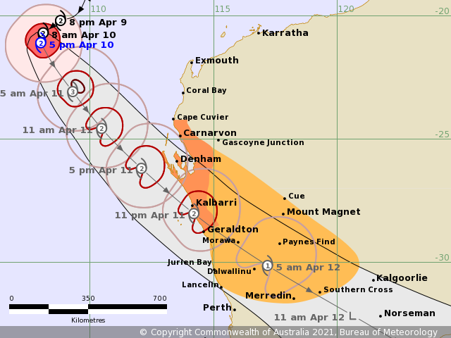
Tropical Cyclone Seroja is beginning to take a more south southeasterly track as it curves around towards the coast
Seroja is expected to intensify overnight, possibly reaching Severe Category 3 as it starts its southeastwards track towards the coast. During Sunday the system will accelerate towards the coast, and should weaken back to Category 2 before it crosses the coast.
The cyclone should gradually weaken as it moves inland on Monday but is still likely to be causing gusty winds east and north of the track, and heavy rain close to the track, as it crosses over the south of the state.
Hazards:
Gales with gusts to 100 kilometres per hour are likely to develop in an area between Cape Cuvier and Kalbarri during Sunday afternoon, then extend further south towards Lancelin and inland into the southern Gascoyne and the Central Wheatbelt late Sunday and early on Monday morning.
Destructive winds with gusts to 150 kilometres per hour are forecast to occur closer to the centre of Seroja as it moves across the coast and into adjacent inland parts. The most likely area to experience destructive wind gusts is on the coast between Geraldton and Denham. People near Denham may see gales as early as midday, tending to as early as dusk further south near Geraldton. The most likely time for onset of gales winds is mid to late afternoon near Denham, and during the evening or overnight near Geraldton.
Seroja will be moving fast, so weather conditions will deteriorate rapidly as it approaches.
Heavy to intense rainfall and flash flooding are likely close to the track of Seroja during Sunday and Monday.
Abnormally high tides could cause minor inundation at the coast between Coral Bay and Lancelin, increasing to serious flooding in the Denham and Shark Bay region and near Kalbarri. Dangerous surf and beach erosion is expected between Denham and Geraldton.
The forecast path shown above is the Bureau's best estimate of the cyclone's future movement and intensity. There is always some uncertainty associated with tropical cyclone forecasting and the grey zone indicates the range of likely tracks of the cyclone centre.
Due to the uncertainty in the future movement, the indicated winds will almost certainly extend to regions outside the rings on this map. The extent of the warning and watch zones reflects this.
This product is designed for land-based communities; mariners should read the coastal waters and high seas warnings.
COVID-19:
What to do if you are self-isolating or quarantining due to COVID-19:
- If you are in an area subject to COVID-19 lockdown restrictions, put your cyclone plan into action now and continue to follow precautions to minimise spread of the virus.
- If you have been personally directed to self-isolate or quarantine due to COVID-19:
- Decide where you will shelter during the cyclone. If it is not safe to shelter in your current location, find alternative suitable premises and wear a mask.
- If a Red Alert has been issued for your location, shelter in place immediately.
- If you are in a storm surge risk area, find alternative suitable premises and wear a mask.
- If you are unable to return to your quarantine location within one hour, telephone WA Police on 131 444 to advise them you have had to leave due to an emergency.
- Regardless of your location, continue to follow COVID-19 precautions and maintain appropriate physical distancing.
ROAD CLOSURES AND CONDITIONS:
Some roads may be closed and motorists are asked to reduce speed and drive carefully.
- Never drive into water of unknown depth and current.
- Road information may also be available from Main Roads WA by calling 138 138 or visiting travelmap.mainroads.wa.gov.au or by contacting your Local Government Authority. The latest road conditions for the Shire of Upper Gascoyne can be found at www.uppergascoyne.gov.au/roadreport
SAFER PLACE:
- Your safest option may be to visit family or friends who live away from the area.
- The Department of Communities has set up three evacuation centres. These include the Irwin Recreation Centre, 1 Ridley Street, Port Denison. Another at the Carnarvon Civic Centre, Camel Lane, Carnarvon and also Shark Bay Recreation Centre located on Francis Road, Denham.
- People who are self-isolating or quarantining due to COVID-19 should find alternative suitable premises and wear a mask.
- If this is not possible, proceed to the evacuation centre and identify yourself to centre staff immediately on arrival.
- Continue to follow COVID-19 precautions and maintain appropriate physical distancing.
- Please take any essential items such as medications and identification to the evacuation centre.
- Pets (except recognised assistance animals) are not allowed inside evacuation centres for health and safety reasons, so you should make alternative arrangements for them.
ANIMAL WELFARE AND PARK CLOSURES:
ANIMAL WELFARE
- Animal owners are encouraged to prepare an animal emergency kit now with sufficient food, water, essential medications, halters and leads, cages and bedding adequate for several days.
- Provide food and water in an area least likely to flood. Provide supplementary feed (such as hay) for livestock.
- For properties in danger of flooding, move all stock to the highest area of the property away from water sources and plains likely to flood.
- Consider raising food stores to elevated ground to prevent flood damage.
- Consider opening internal property gates to allow animals to move to dry ground.
- Be aware of the risks to your animals and your property and keep yourself updated during high-risk periods.
- For more information visit the
Evacuating Animals and Safer Areas for Animals webpages.
PARK CLOSURES:
There are multiple park closures in the warning area. Visit www.emergency.wa.gov.au for more information.
WHAT EMERGENCY SERVICES ARE DOING:
- DFES is monitoring the situation.
- DFES personnel have been deployed to Geraldton in preparation for Tropical Cyclone Seroja.
- The Incident Management Team are planning for all contingencies pre and post impact of Tropical Cyclone Seroja, to ensure the safety of the community.
- State Emergency Service (SES) Volunteers from Geraldton/Greenough, Kalbarri, Shark Bay and Carnarvon are assisting with operations and ready to respond if requested.
- Marine Rescue Geraldton are assisting with radio warnings.
- Local Volunteer Fire and Rescue and Bush Fire Brigades across the Midwest Gascoyne and Pilbara are ready to respond and assist.
IMPORTANT NUMBERS:
- For SES assistance call 132 500
- In a life threatening situation call 000
- For the latest weather information call 1300 659 210 or visit www.bom.gov.au
- For information about road conditions and closures contact local Police or Main Roads WA on 138 138.
KEEP UP TO DATE:
Visit www.emergency.wa.gov.au, call 13 DFES (13 3337), follow DFES on Twitter: twitter.com/dfes_wa, Facebook: facebook.com/dfeswa/, listen to ABC Local Radio, or news bulletins.
During a power outage, your home phone, computer or other electronic devices connected to the NBN will not work. Include a battery powered radio in your emergency kit.
Updates will be provided when the situation changes
|